
On this day, ten years ago (how can it already be that long ago?!?), on 11 March 2011 (“3/11” in American date writing convention) northern Japan was hit by a triple disaster of an unprecedented scale.
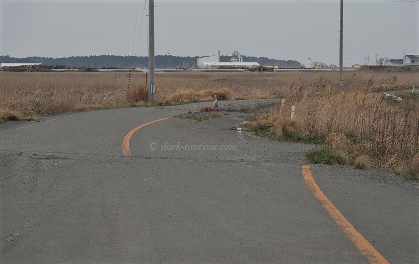
First, one of the most powerful earthquakes ever measured, with its epicentre off the Tōhoku coast, shook the main island of Honshu and caused some destruction. This photo taken near Namie shows a road surface that was broken and shifted by over a metre and a half (ca. 5 feet):
But what came next exceeded everything. The megathrust undersea earthquake triggered a massive tsunami that created waves up to 40m high and reached deep inland, after washing away countless towns and villages along the coast. More than 18,000 people were killed.
And then came the third of the three disasters: the multiple meltdown at the Fukushima-Daiichi nuclear power plant (NPP), caused by the tsunami overtopping the plant’s protective wall and flooding and shutting off emergency power generators so the reactors could no longer be cooled. This led to the biggest nuclear disaster since Chernobyl – three explosions of reactor blocks and three reactor core meltdowns. And it’s not over. The melted cores have still not been removed, and contaminated water keeps accumulating and is stored in ever more tanks at the site.
Here’s a wide view of the Fukushima-Daiichi NPP, taken from a nearby hill, which was the closest we were allowed to get to the stricken site during my April 2019 tour of the area:
The featured photo at the top of this post is a zoomed-in image of the centre of this panorama (already used once before here, last October), so you can see some of the structural damage caused by the hydrogen explosion at one of the reactor blocks.
After the nuclear disaster, which deposited lots of irradiated material over the surrounding lands, an Exclusion Zone was declared, and over 160,000 residents had to be evacuated. Some outer parts of the Zone have meanwhile reopened and some locals have returned, but the core, the Red Zone, remains off limits. A single road runs through the Red Zone that is open to the public to use (cars only), but you are not allowed to stop anywhere. Special signs above the road give radiation readings, such as this one:
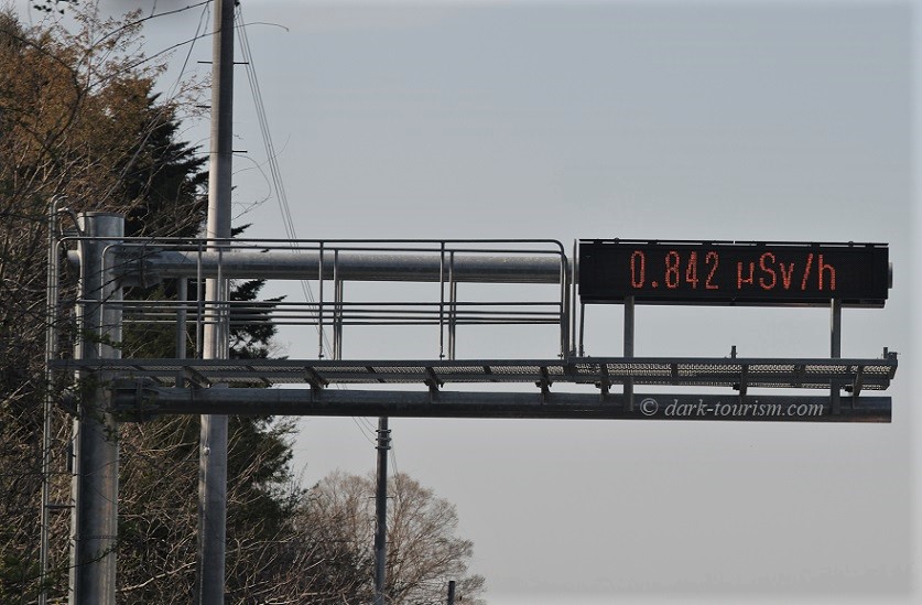
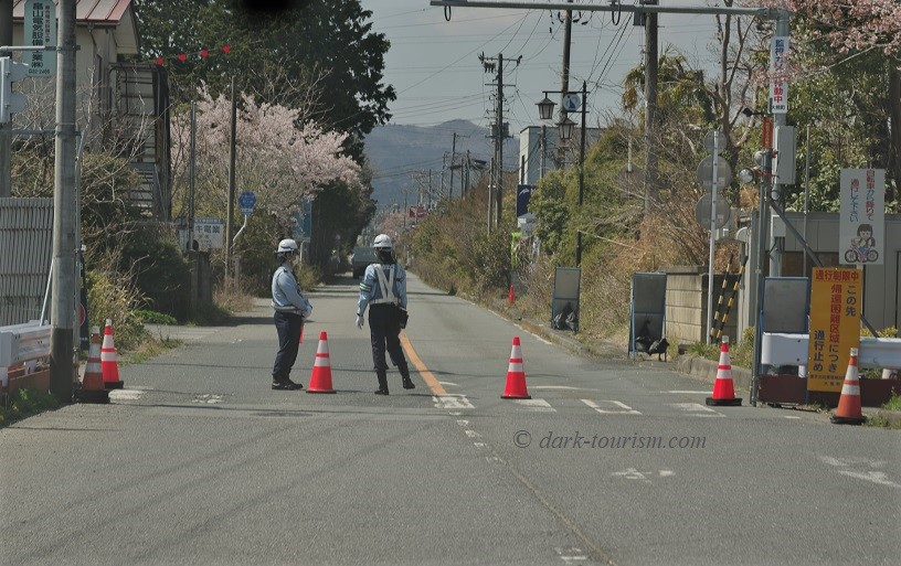
The reading given here is not terribly high, though almost four times the national safety standard of 0.23 microsieverts per hour (μSv/h), so it’s OK to drive through (you get a higher exposure on a plane at cruising altitude), but it would not be a good idea to live permanently in an area with such a level of background radiation. This is why the areas around this road are still off limits. The houses and driveways on either side of the road are fenced off, and intersections are guarded, such as this one:
Those who’ve watched the Netflix series Dark Tourist by/with David Farrier may recall the scene where Farrier and his film crew illegally enter an abandoned pachinko hall (gaming arcade) by this road and nearly got arrested for it. This is that very place:
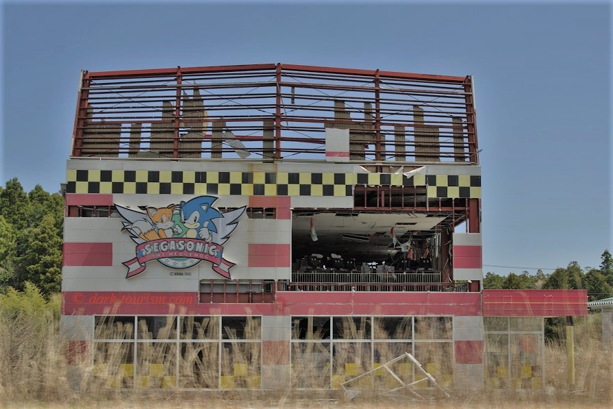
I saw this building early on from the car during my official tour of Fukushima, shortly after we had started in Tomioka, and of course we did not stop to infiltrate this building. In fact, my tour operator went to great lengths on their website to distance themselves from the Netflix series, not just because of the illegality of some of the series’ makers’ actions, but also for the sensationalist and overly negative portrayal of the area. Indeed the fake display of panic over relatively low radiation readings on their dosimeters or the fears about food safety during their lunch break are so sensationalist and off the mark that it’s almost laughable. In fact, the “tour” seen in the series wasn’t an actual tourist tour but a construct specifically for the series; apparently (so I was told by official guides in Fukushima) the other “tourists” seen in that episode were hired by Netflix, so the whole thing was practically a fake.
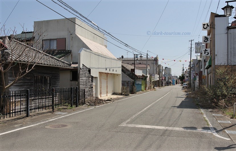
In contrast I went on the real thing, in April 2019. And that tour included an official permit to briefly visit one of the ghost towns within the Red Zone, namely Okuma (since Farrier obviously did not have such a permit, it doesn’t feature in his series). This ghost town was definitely one of the highlights of the tour. Here are a few photos, first one of the deserted main street:
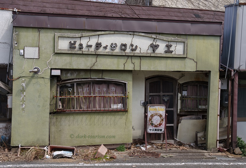
Here is one building, I believe a former restaurant, that seems to show damage caused by the earthquake, though I have no way of knowing whether that was from the 3/11 quake:
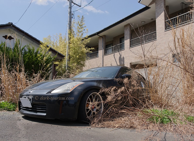
There were a couple of abandoned cars still parked in Okuma, including even this rather flashy sports car:
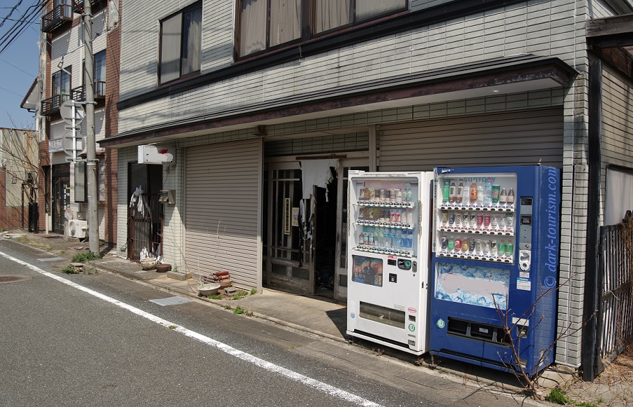
Outside one of the abandoned shops in Okuma, stood two of those vending machines that are so typical for Japan (there’s hardly any vandalism in this country, that’s why they are still so omnipresent). They look like they’re still operational … though we didn’t try:
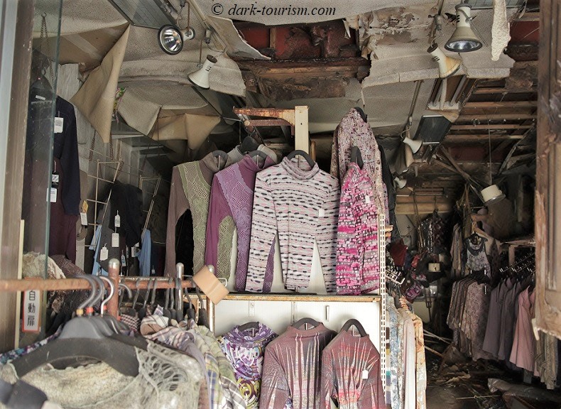
We were not allowed to enter any buildings, but often enough you could get good views inside, such as at this abandoned clothes shop, with its goods still on hangers and only somewhat colour-faded:
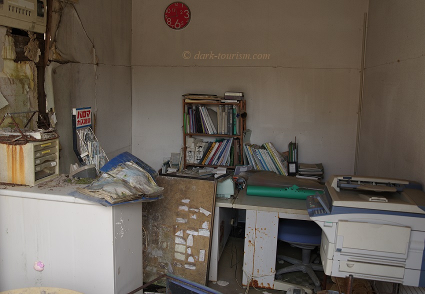
And here’s a peek into an office of some description, with books and files still in place and with a printer that looks like it may still be functional:
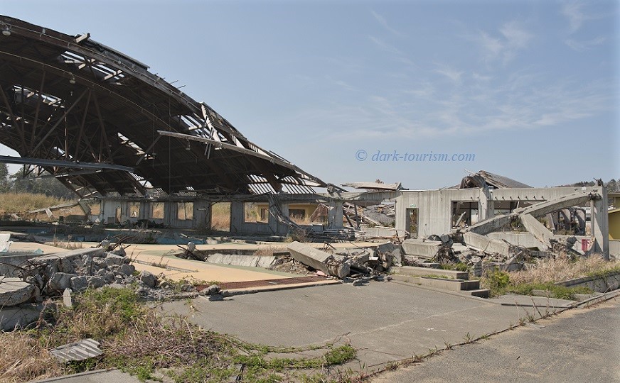
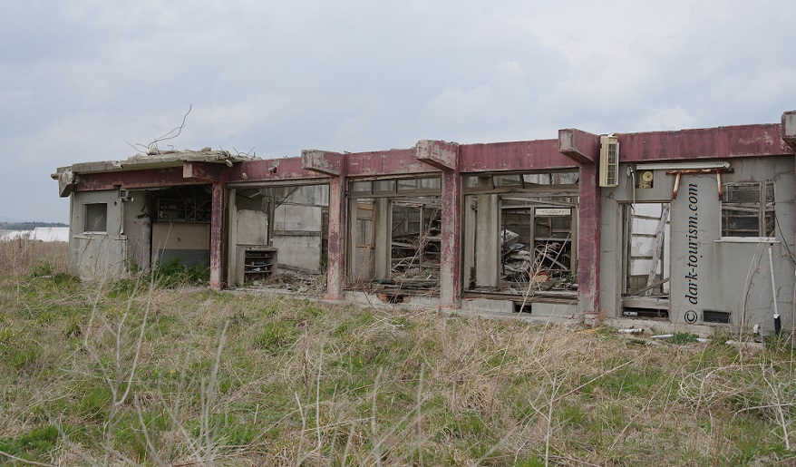
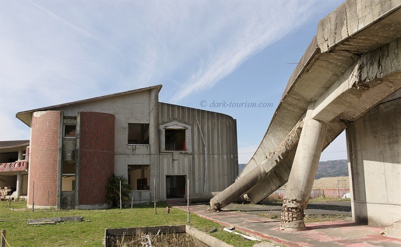
After Okuma we drove on towards the coast south of the Fukushima-Daiichi NPP, namely to a former fish farm (or fish nursery, to be precise) that was destroyed by the tsunami. This is what’s left of the main hall:
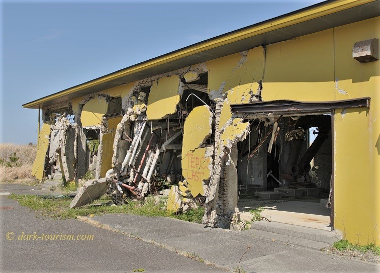
One ancillary building closest to the coastline showed clear evidence of the physical forces that were at play when the wave hit – look at those reinforced-concrete walls bent outwards by the water pushing through the building:
By the way, it was also here that we were given a demonstration of the difference between ambient radiation (i.e. in the air) and radiation at ground level. In the air it wasn’t any higher than those readings above the road, but once the sensor was placed on the ground in a bush by that building, the reading shot up to 13 μSv/h. That’s about as high as I measured on the ground outside the kindergarten of Kopachi in the inner Chernobyl Exclusion Zone. Still nothing to get panicky about (as that “tour group” in the Netflix series did at a reading of 9 μSv/h), but you really should make sure not to inhale or ingest any particles at such a level of irradiation. By the way, I watched a new TV documentary about the Fukushima nuclear disaster the other day, and that featured the discovery of a real hotspot near the sports centre where the Olympic torch relay is to start soon. The measurement there was over 70 μSv/h – and that’s outside the Exclusion Zone!
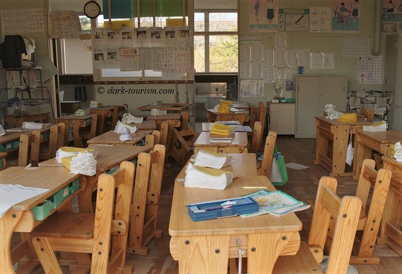
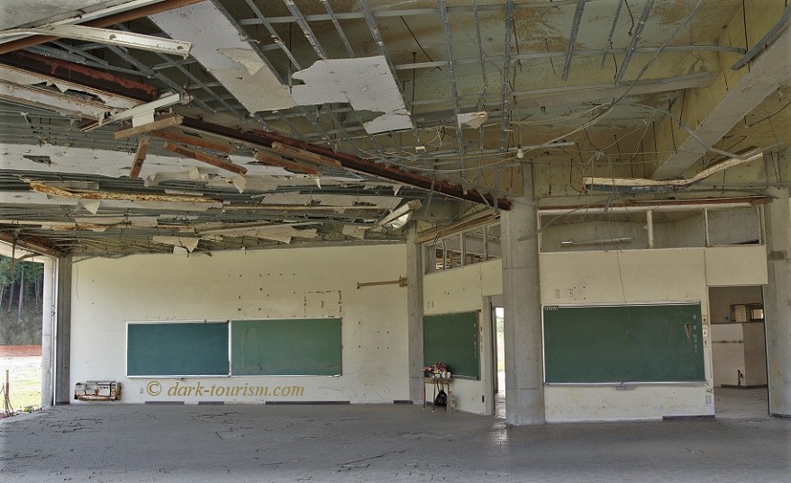
Further on we stopped at an abandoned school. Again, we were not allowed inside, but you could get a good view of some classrooms. It looked like the pupils had only just got up and left:
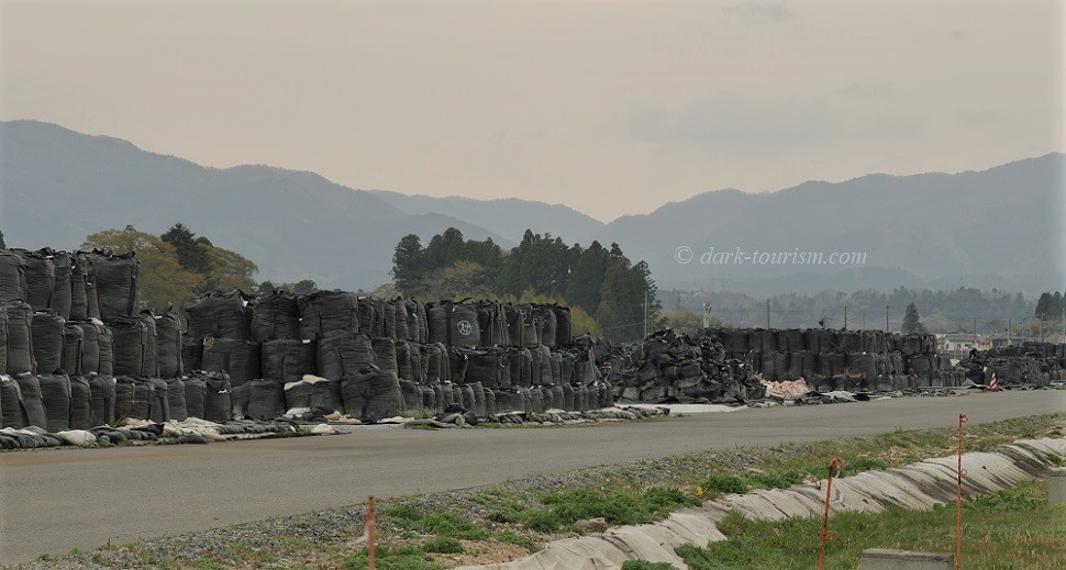
We also drove past some of the storage facilities for those millions of big black plastic bags filled with removed contaminated topsoil. These are just piled high within the Zone, and it’s unclear what’s to become of them longer term, i.e. where they might be permanently stored properly and safely. Here’s a photo of one of the temporary storage sites:
The next day we had another tour, now concentrating more on the parts north of the NPP, including Namie, where we saw lots of the still ongoing recovery efforts, such as the new sea wall designed to soften the force of a possible future tsunami, the rebuilt fishing harbour and an active school (with just a few pupils – most returnees in the reopened parts of the Zone are older residents). But there were also still some tsunami ruins to be seen, such as this one:
On closer inspection we saw plenty of everyday objects, such as a shoe rack stacked with partly decayed shoes, or this rusty teapot:

After the Fukushima tour I travelled on to Sendai, and from there the next day I made my way to Okawa, via Ishinomaki. These are places that were especially badly hit by the 2011 tsunami, and Okawa was the scene of a particular tragedy: it was at the local elementary school that 74 children perished out of 75 for all of Japan. The reasons for this drastic discrepancy were multifold and included a flawed disaster response plan, delays and uncertainty about the best evacuation route on the part of the school staff and culturally ingrained deference to authority. Only a few kids who on their own initiative made a dash for the hill behind the school reached high enough ground and survived. The others were all swept away by the wave, some of the bodies have not been found to this day. I had read about all this in detail in Richard Lloyd Parry’s 2017 book Ghosts of the Tsunami; hence making it to this very place, with some difficulty, really felt like a proper pilgrimage finally achieved.
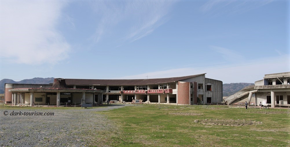
Here’s a panoramic photo of the ruins of the Okawa Elementary School building, which now serve as a memorial:
You are not allowed to enter the ruins, but you can get a good glimpse into some of the ground-floor rooms where the outer walls have been completely taken out:
The most dramatic sight to behold at this place is the semi-toppled reinforced-concrete footbridge that once connected the upper storey of the main school building with the sports complex to its south-east:
This really gives you an impression of how powerful the flood waves must have been here.
Both the Fukushima tour and the pilgrimage to Okawa school were highlights of my April 2019 Japan trip, and certainly the most emotional aspects of it. That’s partly to do with the fact that ten years ago I picked up on the news early and then followed the emerging information and moving images in real time online. I was really shaken by that back then and it’s still haunting me even a decade later. But I was only a distant witness. For the people on the ground it is still very hard to come to terms with this disaster and the personal losses involved. Here’s an example of such a personal story (external link).
As for Fukushima’s nuclear legacy – decommissioning the NPP will probably take decades. Ten years after the meltdowns the molten cores are still in situ. Somehow these will have to eventually be removed by remote-controlled robots, given the high levels of radiation in there.
On the other hand, a recent UN report says that there has been no measurable health damage to the local populace due to radiation from the Fukushima-Daiichi NPP (see here – another external link).
2 responses
Such evocative pictures and descriptions Peter. Thanks for sharing.
🙂 thanks!